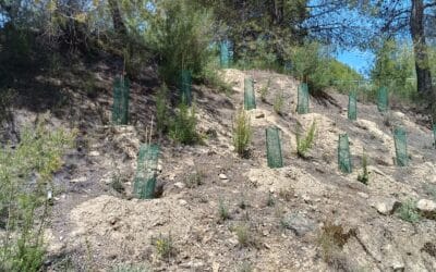
The Association of Tourism Services of the Northwest Region of Murcia has carried out a project to improve the green infrastructure of the "Ruta Verde" (Green Route),...


Calasparra is a perfect destination to discover on foot thanks to its changing landscape between mountain ranges and river valleys. In this section, you’ll find routes to connect with its nature and history: trails through rice fields and centuries-old irrigation channels, unique spots like the Almadenes Canyon or the Cañaverosa Reserve, and cultural tours through the old town and heritage sites such as cave art or the Villa Vieja.
Among the most popular routes are the one that leads to the Sanctuary of the Virgen de la Esperanza, the Argos River trail, and the paths that cross the Sierra del Molino. These are signposted routes, with accessible sections and panoramic views that invite you to stop. Check it out!
Our route begins at the spot known as “Los Viveros,” which is accessed via the turn-off from the road leading to the Sanctuary of La Esperanza. Following the paved path for about half a kilometer north, we find a dirt track on the left that will lead us to the Moratalla River. We cross the riverbed at a designated crossing point, arriving at the area of La Huertecica. This spot is notable for its traditional fruit and vegetable crops. The path then takes us into a lush gallery or riparian forest that grows on both sides of the Segura River's course. A characteristic of this forest is that the vegetation is perfectly adapted to the soil's humidity conditions. This section along the river coincides with the GR-127, which covers a large part of the river's course. The route continues along a path of about 700 m next to the left bank of the river, among white poplars, black poplars, ash trees, hackberry trees, tamarisks, willows, osiers, brambles, oleanders, reeds, common reeds, etc. The water quality in this section of the Segura River allows otters to thrive in perfect conditions, although they are difficult to spot due to their elusive behavior towards humans. We can also see and hear a multitude of songbirds and aquatic birds, such as the common nightingale, the golden oriole, the blackbird, the long-tailed tit, the green woodpecker, the bee-eater, the kingfisher, the grey heron, the cormorant, the mallard, etc. Upon leaving the riparian forest, we take the path on the left that ascends to a viewpoint, from which we can enjoy a panoramic view of the riparian forest nestled among mountains with drought-adapted scrubland. From the viewpoint, we continue along the dirt path through esparto grass fields towards the west. Approximately one kilometer later, we take the first path we find on the left, heading southeast, which will lead us to the Moratalla River. We cross the riverbed again, arriving at the farmhouse known as Casa del Cura. Continuing our journey, we ascend the Lomas de las Torrentas until we reach Cañada Manrique. From this point, a path branches off through a pine forest, which will lead us to a paved road, taking us back to the starting point.
6 km | Difficulty: Low
Enjoy this circular route with a morning walk through the heart of the Rice-Growing Plain to discover the biodiversity of this birdwatching area and its riverside vegetation. An ecotourism date with the river landscapes of the Plain. Camino del Olivarejo towards Villa Vieja River footbridge Canoeing School Rotas beauty spot Birdwatching area Asparagus grove Historic centre More info: <a href="https://calasparrarutasdelarroz.es/ruta-26-06-2021/">https://calasparrarutasdelarroz.es/ruta-26-06-2021/</a>
7,5 km | Difficulty: Low
The "Ruta las Fuentes" is a circular route that tells the story of a time in Calasparra's history when the priorities of the day made the esparto grass industry and the exploitation of the centuries-old salt flats a key part of the town's economic engine. A walk where you'll find a striking contrast of landscapes and different color tones in the earth along certain sections of the path, such as the "Los Coloraos" area, where the predominant color makes this environment a very representative place due to its unique chromatic character. A trail of contrasts where water takes center stage at three spots along the way: the legendary Morcillo, Llano, and Cobre springs. They are part of this extraordinary route alongside the Rambla de los Arcos riverbed and its monumental Aqueduct, witnesses to various episodes in the history of Calasparra. Scenic itinerary: Balsas de Higinio | Fuente Morcillo | Fuente del Llano | "Los Coloraos" area | Fuente del Cobre | Rambla de los Arcos | Salero Viejo | Acueducto de los Arcos. More info: <a href="https://calasparrarutasdelarroz.es/ruta-de-las-fuentes-2023/">https://calasparrarutasdelarroz.es/ruta-de-las-fuentes-2023/</a>
14,32 km | Difficulty: Low
The El Bayo Trail is a circular route of about 6 km that runs through rice fields, irrigation channels, and the banks of the Segura River in Calasparra. It is an easy walk suitable for inexperienced hikers. Distinguished with the Blue Trail award. More info: <a href="https://calasparrarutasdelarroz.es/ruta-30-31-05-2025/">https://calasparrarutasdelarroz.es/ruta-30-31-05-2025/</a>
6,25 km | Difficulty: Low
Circular route from Calasparra passing by the Pozo shelters on the banks of the Segura River, the Casa de las Horyicas, and the rice fields of Soto de la Boquera next to the Esparragal irrigation channel. More info: <a href="https://calasparrarutasdelarroz.es/la-siega-soto-de-la-boquera-2025/">https://calasparrarutasdelarroz.es/la-siega-soto-de-la-boquera-2025/</a>
6,1 km | Difficulty: Low
The GR 127 is a river trail that follows the course of the Segura River from the Cenajo reservoir to its mouth, offering a route that, in its section through the Region of Murcia, crosses key municipalities such as Calasparra and passes through the hamlet of Salmerón in Moratalla. Although its total length is not defined by a single figure, it is divided into significant stages, such as the one from Calasparra to Cieza (35 km), and is characterized by easy to moderate difficulty, as the elevation changes are generally gentle when following the river course, although the length of the stages can be considerable. The essence of the GR 127 lies in its deep connection with water and riverside landscapes. In Calasparra, the route allows hikers to immerse themselves in the heart of the famous rice fields, a landscape of great beauty and uniqueness, especially during the rice growing seasons. The trail also leads to the Sanctuary of Our Lady of Hope, an iconic site carved into the rock beside the river, which is a pilgrimage point and a major tourist attraction. In addition, the GR 127 offers privileged views and access to the impressive Almadenes Canyon, a natural gorge carved by the Segura between Calasparra and Cieza, with its imposing vertical walls and prehistoric caves. The trail also crosses fertile plains, historic bridges, and areas of riverside vegetation, providing a rich and diverse ecosystem. It is a route that allows you to understand the importance of the Segura River in the history and development of the Region of Murcia, offering a peaceful experience deeply connected to the river landscape. The Caravaca de la Cruz Town Council is not responsible for the content of published texts or the state of signage, maintenance, or safety of the routes described.
Por etapas | Difficulty: Medium
The GR 7, part of the ambitious European Long-Distance Path E4 that crosses the continent, traverses the Region of Murcia from east to west for 170 kilometers. As it passes through the region, this GR is of particular interest to the municipalities of Calasparra and Moratalla, offering a hiking experience of varying difficulty, ranging from moderate to difficult in certain mountainous sections. Completing the Murcian stretch can take between 7 and 8 days, allowing for a deep immersion in the regional geography. The trail boasts extraordinary landscape diversity, starting in the Altiplano, with its mountain ranges and plains, before entering the Northwest region. In Calasparra, the GR 7 approaches the Segura River, offering views of the surroundings of the Sanctuary of La Esperanza and the majestic Almadenes Canyon, a natural gorge of great beauty and ecological value. This section allows visitors to appreciate the interaction between the river landscape and the rock formations. As the GR 7 advances towards Moratalla, the terrain becomes more mountainous, delving into mountain areas and Mediterranean forests. The trail winds through rugged landscapes, hidden valleys, and areas of great ecological value, such as the vicinity of Revolcadores, the highest peak in the Region of Murcia. It is a route that not only challenges hikers with its elevation changes but also rewards them with the tranquility of its natural settings, the richness of its flora and fauna, and the authenticity of its villages, offering a complete vision of Murcia's wildest and most inland areas.
170 km | Difficulty: Medium
Spanning 134 kilometers, the GR 251 is one of the "Caminos de la Cruz" (Ways of the Cross) that converges in Caravaca, starting from the Altiplano wine-growing region. This moderate-difficulty trail directly links the municipalities of Calasparra, Moratalla, and Caravaca de la Cruz, offering a fascinating journey through landscapes that contrast vineyards with rugged mountains and river plains. The estimated time to complete it on foot is 5 to 6 days, depending on your pace and stops. The route begins in the plains and mountains of the Altiplano, featuring extensive vineyards and arid landscapes that evoke the essence of the interior. As it moves west, the trail enters the Northwest region, where the scenery transforms. In Calasparra, the path skirts the famous rice fields that the town is known for and approaches the Sanctuary of Nuestra Señora de la Esperanza, a site of great devotion carved into the rock beside the Segura River. Here, the GR 251 often overlaps or crosses with the GR 7 and the GR 127 (Segura River), offering opportunities to diversify your hiking experience. Continuing toward Moratalla, the path crosses mountain areas and river valleys, such as those of the Alhárabe and Benamor rivers, offering panoramic views and the chance to explore untouched natural environments. Finally, the trail culminates at the Basilica-Sanctuary of the Vera Cruz in Caravaca, a perfect finish to a route that connects not only geographies but also traditions and the region's deep connection to its roots. It is a route that combines natural beauty with a strong cultural and spiritual character. The Caravaca de la Cruz Town Council is not responsible for the content of the published texts or the condition of the signage, maintenance, or safety of the described routes.
134 km | Difficulty: Medium
The Sendero de la Mulata is a circular route that explores the rural and forest surroundings of Calasparra. It combines sections of track with easier paths, passing through pine forests, scrubland, and cultivated areas. It is a low-difficulty route, suitable for a family walk or for those looking to enjoy nature in a relaxed way. It offers the opportunity to observe local flora and fauna and enjoy the tranquility of the Murcian countryside.
7 km | Difficulty: Low
This is the shortest route in the Calasparra trail network, designed for quick and easy access to Cabezo Negro, a small elevation that serves as a natural viewpoint. Despite its brevity, it offers a different perspective of the surroundings, allowing visitors to observe nearby landscapes with minimal effort. It is perfect for a very short walk or as a complement to longer routes.
750 m | Difficulty: Low
The Ruta de la Vega Arrocera is a deep immersion into the most emblematic agricultural landscape of Calasparra. The trail follows flat tracks across extensive rice fields, allowing visitors to observe the entire cultivation cycle up close, from the flooding of the fields to the harvest, depending on the time of year. It is a highly visual and sensory route, where you can enjoy the reflections of the sky in the water, the changing colors of the rice fields, and the sounds of water birds. Ideal for a peaceful and cultural walk to understand the importance of this crop in the region.
8 km | Difficulty: Low
Despite its short distance, this route has a moderate difficulty due to a concentrated ascent to reach a high point in the Sierra de San Miguel. The effort is rewarded with spectacular panoramic views of Calasparra, its rice fields, the río Segura, and the surrounding sierras. It is an ideal route for those looking for a quick but rewarding hike, with an elevation gain that offers a small challenge and an immediate visual reward.
2 km | Difficulty: Medium
A trail designed for tranquility and enjoyment of the agricultural and forest landscape near the town center. It follows flat and gentle paths, crossing cultivated areas, small woodlands, and Mediterranean scrubland. The name “Paz” suggests its relaxing nature and its suitability for meditative or family walks. It is an accessible route that allows visitors to disconnect and reconnect with nature close to the town.
5.2 km | Difficulty: Low
This route ventures into the impressive Cañón del Río Argos, a gorge carved by water that offers landscapes of great natural beauty. The trail winds along the river through dense riverside vegetation and towering rock walls. The moderate difficulty is due to some more technical or uneven sections of terrain. It is an opportunity to explore a unique river ecosystem, with pools and small waterfalls, and to enjoy the coolness of the canyon, a refuge during the hottest months.
7.4 km | Difficulty: Medium
These trails are key routes to reach the Santuario de Nuestra Señora de la Esperanza, a place of great devotion and natural beauty carved into the rock beside the río Segura. Each variant offers a slightly different approach, but all share the connection to this unique site. The Sendero de Peregrinos is the most traditional, while Atajo and El Olivarejo provide alternative options. All run over easy terrain, often along the river or through wooded areas, ideal for a शांत and reflective walk to one of the most iconic places in Calasparra.
5 km - 6 km | Difficulty: Low
A short and very interesting route that combines heritage and curiosity. This trail focuses on the ascent to Castillo de Calasparra, offering panoramic views of the town and the vega. The main highlight is the “Tunelillos”, a series of passages carved into the rock that were part of old communication routes or fortifications, providing a unique and somewhat mysterious experience. It is a family-friendly and educational walk, perfect for a quick introduction to local history.
2.4 km | Difficulty: Low
This route is a pleasant walk through the heart of Calasparra, designed to discover the town’s cultural and historical heritage. It follows the streets of the old town, passing through emblematic squares, historic buildings, and landmarks such as Iglesia de San Pedro Apóstol and Castillo de Calasparra. It is ideal for a relaxed afternoon stroll, to get to know the essence of the town and its history, and to enjoy the local gastronomy in its bars and restaurants. Its low difficulty makes it accessible to everyone.
2.5 km | Difficulty: Low
The Association of Tourism Services of the Northwest Region of Murcia has carried out a project to improve the green infrastructure of the "Ruta Verde" (Green Route),...

The Northwest Tourism Services Association continues to advance the modernization and digitalization of the tourism offerings in its member municipalities by acquiring...

La Mancomunidad de Servicios Turísticos del Noroeste de la Región de Murcia continúa avanzando en la transformación del modelo turístico del territorio con la...

A route is a planned journey that allows you to explore different places in an organized way, whether on foot, by bike, or by vehicle. Along the way, you can discover...
PRESS RELEASE Boosting the tourism sector in Northwest Murcia through a business mentoring program funded by NextGenerationEU The Northwest Region of Murcia, under the...

The Region of Murcia consolidates its position as the second autonomous community with the highest number of Blue Trails in Spain, reaching a total of 32 distinctions....
Accommodation
Businesses
Gastronomy
Places
Routes
Accommodation
Businesses
Gastronomy
Places
Routes